Showing posts with label shoulder. Show all posts

Thursday, June 7, 2018

We really need to fix Old Columbia Pike

Recently, I we had some nice weather in the area, so I just wanted to take my bike out for a little shake down before I begin my summer commutes on it.   Living in an area surrounded by busy, high volume roads, I generally seek out the safest, quietest routes.   

This was an unplanned route, but in my head, I thought I could get down to Randolph Rd, then turn around and return via Old Columbia Pike.   So I started out heading south knowing I was going to ride under the ICC via the bike trail on the east side of the interchange.    It's a bit isolated for me, generally, it's not visible from the road, and therefore I find this trail to be unsafe.   In retrospect, this trail should have been built for better visibility, either up higher, next to the roads, or along the neighborhood streets.  Hopefully in the future, new trails will be built keeping visibility in mind. 

Click image for larger image of the area I rode in the Fairland Area. 
Additionally, as you can see from my route, I didn't quite make it down to Randolph.  Unfortunately, there's no direct route southbound once I made my way south through the ICC interchange.   I would have had to ride through Calverton Park, local streets, and generally take a long way to get where I wanted to go.  I would be better if we just connected a trail to Randolph along the property frontage of Verizon on the east side of US-29 from Fairland Rd.   Certainly, explore the map in detail more to see the roads and connections that are needed. 

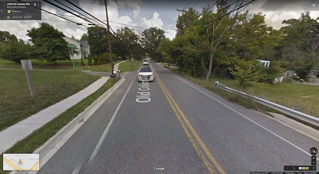
On my return, I wanted to avoid Old Columbia Pike, so I crossed and road zig-zagged through some neighborhood roads to avoid the narrow or non-existent shoulders and high volume of traffic.   North of Fairland Rd, and especially the point where Old Columbia crosses over the ICC, there is no extra room on the road for vulnerable users.   The section northbound on Old Columbia Pike could use a shared-use-path along the east side.   Even if it was a sidewalk, I would be on it as drivers failed to give me even 3-ft of clearance.   

https://photos.app.goo.gl/dU2mlVX8KnqRVVIV2
Looking North on Old Columbia Pike at the ICC Bridge


Old Columbia Pike is a major connector for biking in the area between Burtonsville and White Oak.  Planning phases come and go, yet I still have no safe place to ride. 

Who is going to take the lead and get the money needed to build safe riding paths along Old Columbia Pike? 


Tuesday, July 18, 2017

Public Comment for the MD 28, Norbeck Road, and MD 198, Spencerville Road/Sandy Spring Road project AW068_11 (was MO886_11)

Please submit a public comment about MD-198 by July 19th!


Here's my message -- thanks Sebastian for producing a template that made it easier to put these items together.  


To: jbeck@sha.state.md.us
Cc: eric.luedtke@house.state.md.us, Tom.Hucker@montgomerycountymd.gov, craig.zucker@senate.state.md.us


Dear Mr Beck,

As a regular user of MD 198, I am pleased to see progress at making this road safer for bicyclists, pedestrians, and drivers. That being said, there is room for improvement.

I have been a long time resident of Burtonsville and have been a strong supporter of rebuilding this community into a destination via my participation in the design of the Burtonsville Crossroads Neighborhood Plan and continuing work through the Maryland Bicycle and Pedestrian Advisory Committee (MBPAC) and Montgomery County Bicyclists Advisory Group (MCBAG).   I envision and walkable and bicycle friendly business district with bicycle connections between all surrounding communities and parks.   To make this happen, I urge the State Highway Administration to make the following revisions to the MD 28/198 Corridor Improvement Study.

For all All of MD198/MD28
  • I support bike-friendly facilities, in particular, the off- road shared-use path on one side of MD 198 in areas with few driveways or curb cuts.  Areas that currently have a high density of access points should be reconfigured to reduce curb cuts/access.   The path and roadway should be separated by a green space buffer wide enough for tree planting to provide shade. 
  • The shared-use path should be wide enough for two directions of bicycles and pedestrian traffic and designed to be as straight as possible and for a reasonable bicycle cruising speed of up to 15-20 miles per hour. 
  • Crosswalks should be announced with markings and signage to warn drivers about crossing bicyclists and additional markings should be made where driveways cross the trail, possibly with raised crosswalks to slow drivers and raise awareness to trail users. 
  • High-speed, right- turn slip lanes that turn across the trail should be reconfigured to slow down turning vehicles and improve visibility of cyclists and pedestrians.
Critical recommendations for SHA Project Management Division, Segment D (Burtonsville):
  • Comply with the Burtonsville Crossroads Neighborhood Plan by providing a landscaped median with breaks to establish a grid of local streets, enhance safety, and improve access to businesses.  This would look more like the Alt-3 Access Management Profile.  
  • Lanes should be narrowed from 11 ft to 10 feet to discourage speeding and bring a more residential/commercial quality to the business district.
  • In addition to lane with reductions, speed limit through Burtonsville Business District should be set to a maximum of 25 mph.
  • Overhead utilities should be cleaned up and buried.
  • Widen grass buffers between sidewalks and road to 6 ft to allow streetscaping.
  • Widen bike lanes to 5 ft and add 2 ft buffer from travel lanes to improve safety.
  • Add traffic circles at Old US-29 and MD-198 and at Old Columbia Pike (diagonal intersection) and MD-198.  This will facilitate those who need to make U-Turns since left turns will be essentially eliminated through the Business District with the exception of a traffic light at the Burtonsville Town Square intersection.
Critical recommendations for SHA Project Management Division, Segment E (West Laurel):
  • Add second turn lane from McKnew Road to MD 198 or add a signalized intersection at Cedar Tree to relieve the aggressive behavior people exhibit when attempting to leave the community.  
  • Drivers leaving McKnew Rd to MD-198 should not have any turns while MD-198 through traffic is green.  The limited visibility and speed of traffic in this segment makes even right-on-red dangerous.   Additionally, a bicyclist on the shoulder has no bailout area due to the volume and speed of traffic which is a problem when vehicles routinely make continuous right-hand-turns on red (without a stop). Even with a stop, the vehicles are pulling well into the bicyclists useable shoulder area. 
  • The MD-198/McKnew intersection should be completely controlled, including left turns with red-arrows from MD-198 to McKnew to prevent the frequent collisions that occur today.   
Critical recommendations for the SHA District 3 office include:
  • Allocate funding for intersection improvements at MD 198 and Peach Orchard Rd.
  • Install traffic signal at Burtonsville Town Square.
  • Install speed activated signs in 25 and 30 mph speed zones.
  • Provide crosswalks for people to safely cross MD 198 (see Coalition to Fix 198 document for locations).
Critical recommendations for Montgomery County include:
  • Install gateway landscaping and signage at entrance to Burtonsville retail district.
  • Accelerate funding for Burtonsville Access Road.
  • Draft amendment to state legislation to clarify applicability of speed cameras.
  • Construct sidewalk on McKnew Road to connect to MD 198.
  • Extend Sidewalk on North side of MD-198 from 4140 Sandy Spring Rd to McKnew Rd to allow pedestrians a place to walk while not forcing crossings midway.  Also allows safer access to bus stop.

Thank you for the opportunity to comment on the study. I encourage you to review the full report developed by the Coalition to Fix MD 198 (download at: https://goo.gl/LUCzepfor more recommendations.


Sincerely,

Stephen Ashurst


Wednesday, January 27, 2016

Snow Fixed the Problem

This is one intersection I'm glad is still blocked by snow.   Impatient drivers find it necessary to drive on the shoulder to make a right-on-red.  Although the lane configuration was never designed for this, everyone seems to find it necessary to drive off the pavement (in the mud sometimes) and within inches of sideswiping vehicles stopped to make a left turn, just to save a minute.  Thanks snow for fixing the problem!  This should not be two lanes, and when the snow was piled up on the shoulder, the intersection became calm and useable once again.


How people usually drive.
Photo with snow blocking the excess pavement.

Although this fixes the vehicle turn problem temporarily, a permanent solution would include building a curb and sidewalk here, removing the excess pavement to prevent people from attempting to squeeze by on the right, and so people walking from the bus stop have a safe way into the neighborhood.


Saturday, May 24, 2014

Pinch point, Old Columbia Pike, Burtonsville

Southbound on old Columbia pike leaving Buttonsville, I've had many a close call/near miss at this pinch point where the shoulder, wide enough before and after, shrinks in size on a curve which many cars judge incorrectly and drive into the shoulder area, leaving little room for me to move right to avoid being hit.  

Please review the short video of this spot.  Hopefully this choke point can be removed.